QHF March 2021 - qgis/QGIS GitHub Wiki
Join in on the QGIS INTEGRATED open day. Our amazing lineup of presenters will show you how QGIS can work in a network with other software and programs to create dynamic and shareable spatial data, maps, and systems.
If you would like to discuss topics on our QGISOpenDay, please add sections below for each discussion along with the proposed time and agenda.
Simply join the meeting on Jitsi and say hi! https://meet.jit.si/QGISOpenDay (Note this room is just for organising. To watch the programme use the YouTube live stream links below)
To keep up to date with QGIS Open Day events, please join the Telegram channel.
Virtual events will be taking place online (see links below) and in the Telegram chat room, and with many events also being live-streamed on YouTube. See the individual event descriptions below for an indication of where to join each event.
QGISOpenDay 26th March 2021
| No | Name | Time | Coordinator | Language |
|---|---|---|---|---|
| 1 | Input and Mergin: collect data, sync and collaborate with ease | 08h00 UTC | Saber Razmjooei | English |
| 2 | Using QGIS, Input, Mergin, and Metabase to conduct a WASH survey in the Waterberg | 09h00 UTC | Gavin Fleming | English |
| 3 | Using QGIS and a laser cutter to make 3D contour models | 10h30 UTC | Raymond Nijssen | English |
| 4 | Seamless fieldwork with QField & QFieldCloud | 12h00 UTC | Marco Bernasocchi | English |
| No | Name | Role | Contact |
|---|---|---|---|
| 1 | Amy | Session planning and speaker coordination | Contact Amy via the Telegram Channel username @Amz |
| 2 | Zinzi | Publishing platform and workflows | Contact Zinzi via the Telegram Channel username @zinzixakayi |
| 3 | Nicholas | Event promotion - via mailing lists | Contact Nicholas via the Telegram Channel username @Nicholas |
| 4 | Seabilwe | Social Media | Contact Seabilwe via the Telegram Channel username @Seabilwe |
Time: 26 March 2021 08h00 UTC.
Duration: 1 hour
Venue: Youtube Live Stream Link
Presenter: Saber Razmjooei
"Input app is a free and open-source mobile app for Android and iOS. Input app is based on QGIS with a simplified and intuitive interface for easy data collection in the field.
The app comes with a built-in synchronisation tool, called Mergin service, enabling users to collaboratively edit the same data. In addition, the Mergin service can:
1- be accessed in QGIS, through a plugin to sync data from your PC
2- linked to a Postgresql/PostGIS database for offline use
3- generate work-packages for efficient survey "team management"
Host: Open Day team
Time: 26 March 2021 09h00 UTC.
Duration: 1 hour
Venue: Youtube Live Stream Link
Presenter: Gavin Fleming
Host: Open Day team
A practical example of how QGIS, the Input app, Mergin, mergin-db-sync and Metabase were used to conduct a WASH (WAter, Sanitation and Hygiene) survey in the Waterberg district of Limpopo Province, South Africa. During 2020, Kartoza participated in a USAID Resilient Waters funded project to produce a Strategic Environmental Management Plan (SEMP) for the Waterberg Biosphere Reserve (WBR). Besides all the GIS analysis and map production we did with QGIS, PostGIS, GRASS and other FOSS tools, we were called into support the social component of the project. Biosphere Reserves are part of the UNESCO Mand and the Biosphere programme, which means human impacts and livelihoods are a critical component of Biosphere Reserve plans and objectives. The WBR supports a huge tourism industry and has many wealthy landowners yet many human settlements lack sufficient access to water and sanitation and still depend directly on natural resources for heating and cooking. We set up and managed a survey using these tools and trained three field workers. They spent three months in the field interviewing two thousand people in sixty settlements, with all survey data successfully synchronising so the project team could analyse and visualise it.
Time: 26 March 2021 10h30 UTC.
Duration: 1 hour
Venue: Youtube Live Stream Link
Presenter: Raymond Nijssen
Host: Open Day team
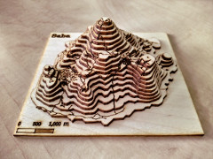
A bit of fun using QGIS to generate contour maps and other features and then converting the larger into a 3D model with the help of a laser cutter.
Time: 26 March 2021 12h00 UTC.
Duration: 1 hour
Venue: Youtube Live Stream Link
Presenter: Marco Bernasocchi
Host: Open Day team
QField is an application that focuses on efficiently getting GIS fieldwork done. QField combines a minimal design with sophisticated technology to get data from the field to the office in a comfortable and easy way. QField works with QGIS allowing users to set up maps and forms in QGIS on their workstation, and deploy those in the field. Leveraging QGIS' data providers - OGR, GDAL, PostGIS, and more - QField supports a wide variety of vector and raster formats that can be locally stored or accessed remotely and synchronized with WiFi, USB cable or mobile network.
You can do this too! We really encourage others to follow our initiative, using the wiki page link below to organise your plans (just add a section below the last one). You can host virtual meetups in the Jitsi room, plan your next steps to take QGIS further down the road to world domination and much much more. We encourage language and region-specific huddles, documentation improvement sessions, bug fixing, making beautiful maps, and working together to do amazing things with QGIS.
We would really love to see more events offered from our country user groups and broader user base. The content can be at any skill level and in any language you like, and the times can overlap if needed. So please feel free to organise your activities on this wiki page. The QGIS Open Day is also an ideal time to hold virtual country user group meet-ups - please share your activities on the open day schedule, so that even people from outside of your country user group can benefit from your presentations. Contact me (see below) if you need help adding your events to the wiki page.
You can spread the word! We have prepared the following materials so that you may easily copy and paste the relevant contents to publish on your media platform of choice to let others know about these awesome events.
About QGIS Open Day
Dear QGIS Users
On Friday, 26 March 2021 we will be holding our monthly QGIS Open Day! What is a QGIS Open Day you may be wondering to yourself? It is an initiative to replace the wonderful community meetups we used to hold every six months when times were different. Like our in-person meetings, the event is organised on the principle of self-organisation and community participation.
Programme
- QGIS INTEGRATED (The open day that shows QGIS working as part of with other software and programs to create dynamic and shareable spatial data, maps, and systems)
Where to watch
Please see the event wiki page at QHF-March-2021 Wiki for all the details of times and links for participation.
All of the YouTube live-streamed events will be recorded and made available to users who couldn't make the live events. Youtube live streams sometimes take 24 hours to be available for catch-up viewing. Be sure to check back here for updates!
Participants are kindly reminded to please read and observe our QGIS Code of Conduct and Diversity Statement to make these events a great experience for everyone!
Please contact me, Zinziswa Xakayi by email [email protected] or via the Telegram Channel username @zinzixakayi if you have any queries or need help setting up events.
We look forward to seeing you there!