Solution for Blockchain : - planb-x/Blockchain GitHub Wiki
This blog proposes a secure, Digital Cadastral implemented on the Public Block Chain Ledger as the modern version of “the cadastre”
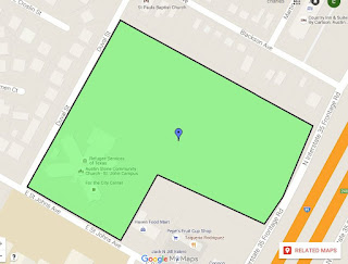
As shown below, all property boundaries, of arbitrary complexity, can be easily represented as a polygon of GPS coordinates. These can also be displayed, on any freely available commercial mapping system, Google maps is used in the example below.
This basic concept, combined with the almost universal availability of GPS, and mapping services within all smart phones, underpins this approach and adds true security to the old insecure world of land registration and transfers. This solution closes the existing vulnerability of "which property" that exists within existing land registry and transfer systems today.
Accuracy in land surveys
The purpose of a land survey is to accurately map and designate land boundaries. Any inaccuracies can lead to potential legal issues down the track. It is generally accepted that a positional accuracy of 20 mm, plus 50 parts per million is required. Typical real-time kinematic GPS system are accurate to around 20 mm horizontally and 30-40 mm vertically. Such systems are regularly deployed within Australian farms today, as part of GPS based farming practice systems. Hence the underpinning technology exists,and due to increased usage will follow a decreasing price and increasing global availability curve in the future; this technology maps into the proposed solution today. It is envisioned that a risk management approach be applied to the required level of accuracy required in any given circumstance, using the ability of the proposed system to tightly align adjacent boundaries, thus removing a significant traditional risk from the "total" system.
The Proposal
This proposal for the land registry specialist Public Block Chain Ledger, makes use of GeoJSON (Polygon) and Google Maps, the semantics (real property description) of a title transfer will be codified, and orchestrated within in the Public Block Chain Ledger and related protocols.. GeoJason has been chosen over KML, as the most suitable for modern digital systems.
The solution as secured by a Public Block Chain Ledger, is secure, makes use of global Secure Identities, is freely accessible to all, heralding a new generation of services. Ownership is authenticated via the holding of HSM backed Elliptic Curve key-pairs.
GeoJSon Example
Residential property { "type": "Polygon", "coordinates": [ [30, 10], [40, 40], [20, 40], [10, 20], 30, 10 // up to 8 decimal places to give 1 mm accuracy "accuracy": [20, 40] // 20 mm hor, 40 mm vert ] }, "properties": { "guid":"9a3aa3b3-c136-414e-824d-2739317684f4", // global unique property identifier "propertyId":"<SHA265(polygon values)>", "type":"Residential", "lot": "3", "plan": "RP 54367", "area":"8,530 SQM", // calculated from polygon "locality": {"county": "parish":"council"} "address":{"number":"street": "city":"state":"postcode"} "encumbences": "value" }
This polygon can be easily displayed on industry standard mapping solutions such a Google Maps or Google Earth.. The codification of the boundaries of any real estate, supports automatic, conflict and over lap process as part of the block chain ledger, protocols. Some existing government departments make use of KML: files, which can easily be converted to GeoJSon..
Processing
The GeoJSon is processed though a SHA265 transform, which is feed into the ECDSA signatures of the registrar, buyer and seller Block Chain Ledger transaction..
The advantage of including on a specialist Public Block Chain Ledger, is that it can be orchestrated with payment Block Chain Ledgers to produce "legal" finality and "real-time" settlements.
Many of the existing parties which extract value from the manual process today, will simply disappear, producing a more efficient and secure result for all parties.