2026 Joint OGC – OSGeo – ASF Code Sprint - opengeospatial/developer-events GitHub Wiki

| Sponsored by | Hosted by | |
|---|---|---|
|
|

|
|
This sprint will cover several OGC approved and candidate standards. Several OSGeo and Apache projects will participate. If you are new to Code Sprints, please check the mentor streams below.
For a glance at the topics of previous Joint OGC ASF OSGeo Code Sprints, please read the following engineering reports and GitHub issue:
- 2024 code sprint, https://github.com/opengeospatial/developer-events/issues/127
- 2023 code sprint, https://docs.ogc.org/per/23-025.html
- 2022 code sprint, https://docs.ogc.org/per/22-004.html
- 2021 code sprint, https://docs.ogc.org/per/21-008.html
The code sprint is supported by the OGC Testbed-21 initiative and will include activities related to the GEOINT Imagery Media for Intelligence, Surveillance, and Reconnaissance (GIMI) standard.
The code sprint will take place from the 27th to the 29th of January 2026. The sprint will be preceded by a pre-event webinar, to take place online on January 22. This webinar will set the context for the upcoming sprint and participants are encouraged to attend, as this information will not be repeated at the welcome session.
Other than the pre-event webinar, the meeting will be hybrid and will take place at USGS Science Center in Fort Collins, Colorado, USA and on the OGC events discord server. If you are attending in person, please check the travel info section.
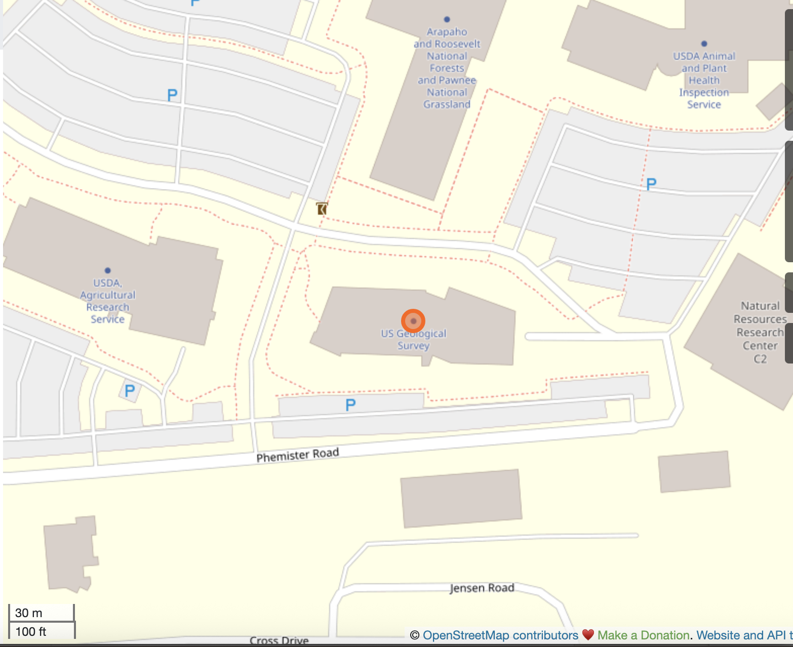
USGS Science Center in Fort Collins, Colorado, USA: Fort Collins Science Center, 2150 Centre Avenue, Bldg C, Fort Collins, CO 80526.
Join Discord from Windows, Mac, iOS or Android: https://discord.gg/3uyaZZuXr3
Discord app download: https://discord.com/download
Most text channels are also bridged on Matrix: https://matrix.to/#/%23ogc:matrix.org
At this sprint, all the online meetings will take place on teams. See the details here. The discussions will still take place on the discord text channels.
Participants can apply for funding to offset their travel costs.
The code sprint will be held on Mountain Standard Time (GMT-7). You can check here the time for your location.
This is the schedule for the main track. For the mentor stream, please check the detailed schedule here.
| Date | Time | Day/ Activity | Discord channel |
|---|---|---|---|
| 2026-01-22 | Day #0 (pre-event): Welcome Webinar audio recording | ||
| 07:00 - 07:10 | Welcome remarks - Joana Simoes | V:🏛 #Main Stage | |
| 07:10 - 07:20 | Overview and Sprint Goals for participating OGC working groups and OGC Testbed 21 - Gobe Hobona | V:🏛 #Main Stage | |
| 07:20 - 07:30 | Overview and Sprint Goals for Apache projects - Martin Desruisseaux | V:🏛 #Main Stage | |
| 07:30 - 07:40 | Overview and Sprint Goals for participating OSGeo projects - Angelos Tzotsos | V:🏛 #Main Stage | |
| 07:40 - 07:55 | Overview and Sprint Goals for the GEOINT Imagery Media for Intelligence, Surveillance, and Reconnaissance (GIMI) Standard - Joe Stufflebeam | V:🏛 #Main Stage | |
| 07:55 - 08:00 | Q&A | V:🏛 #Main Stage | |
| 2026-01-27 | Day #1: Kick-Off | ||
| 09:00 - 10:00 | Welcome session | V::📣 teams | |
| 10:00 - 12:30 | Practical Work | ||
| 12:30 - 13:30 | Lunch | 🍜 | |
| 13:30 - 16:00 | Practical work | ||
| 16:00 - 17:00 | Daily Brief Back | V::📣 teams | |
| 2026-01-28 | Day #2 | ||
| 00:00 - 08:00 | DQ4IPT Breakout [online only] | V::📣 teams | |
| 09:00 - 10:00 | Practical work | ||
| 10:00 - 10:30 | Stand-up | V::📣 teams | |
| 10:30 - 12:30 | Practical work | ||
| 12:30 - 13:30 | Lunch | 🍜 | |
| 13:30 - 14:00 | Breakout: OGC API - Joins on pygeoapi demo [online only] | V::📣 teams | |
| 13:30 - 16:00 | Practical work | ||
| 16:00 - 17:00 | Daily Brief Back | V::📣 teams | |
| 2026-01-29 | Day #3: Final Day | ||
| 09:00 - 10:00 | Breakout: Handling big images | V::📣 teams | |
| 09:00 - 10:00 | Practical work | ||
| 10:00 - 10:30 | Stand-up | V::📣 teams | |
| 10:30 - 12:30 | Practical work | ||
| 12:30 - 13:30 | Lunch | 🍜 | |
| 13:30 - 15:00 | Practical work | ||
| 15:00 - 17:00 | Demos & Wrap-up | V::📣 teams |
If you would like to add any items to the schedule, just edit the agenda above and add another row on the relevant section. Example:
| | 11:00 - 12:00 | pygeoapi meeting | [#Jitsi Room]()
Meeting ID: 253 284 970 454
Passcode: Hi2xa6on
Phone Number: +1 202-640-1187 (Washington, D.C.)
Phone Conference ID: 859 873 677#
Find a local number | Reset dial-in PIN
Joana Simoes (OGC), ✉️, discord: @doublebyte.
Gobe Hobona (OGC), Scott Simmons (OGC), Angelos Tzotsos (OSGeo), Tom Kralidis (OSGeo), Martin Desruisseaux (ASF) and Brian Proffit (ASF).
Registration is free for everyone. You may register here. At the time of the event, only registered participants will have access to the relevant Discord channels.
- OGC API - Records
- OGC API - Publish-Subscribe Workflow
- OGC Coverages with Coverage Implementation Schema (CIS) and WCPS
- Training Data Markup Language for AI
- OGC API - Connected Systems
What activities or tasks might OSGeo and Apache projects work on together with OGC working groups during the 2026 joint code sprint?
Post your ideas as comments in this GitHub Issue.
In this section, projects and working groups have the chance to do a five minute pitch to introduce themselves. This is an excellent opportunity to draw attention to the project/working group and invite others to collaborate on specific tasks during the code sprint. If you are interested in doing a pitch, please record a short video (5 mins) and link to it below. We would recommend adding your pitch before the pre-event webinar, on the 22nd of January, 2026 at 14 UTC. We will refer to the pitches during the webinar.
Sample pitch on youtube
If you are coming to an OGC Code Sprint for the first time, you may be a little lost and confused about what you should do when you get there. That is why we will have an onboarding day, to help you get started in the OGC Community. In the Discord server, you will find a section called "mentoring", which contains multiple channels. On day 1 of the code sprint, we will feature a stream of tutorials at the V::📣 teams meeting
On the first day of the code sprint, there will be a mentor stream onboarding session at the V::📣 teams meeting.
27th of January, 10:10 - 10:20 GMT-7 - https://www.timeanddate.com/worldclock/meetingtime.html?iso=20260127&p1=224&p2=179&p3=16&p4=75&p5=240&p6=136&p7=133
If you would like to present a hands-on, entry-level tutorial, just add an entry below, following the same format of the Sample Tutorial (you can see here examples from a previous sprint). Please choose a time slot on day 1 (the 27th), that does not conflict with any of the scheduled events.
This tutorial will cover how to create, publish and discover data which is catalogued with the OGC API - Records standard, using pygeometa, pygeoapi, pycsw, and the QGIS desktop application. At the end of the tutorial, you should be able to add your own OGC API - Records endpoints to discover and search for data. To follow the tutorial you need the latest versions of pygeometa, pygeoapi, and QGIS (no plugins needed).

Technologies: QGIS, pygeoapi, pycsw, pygeometa
Requirements: A basic understanding of OGC APIs and OGC Web services (OWS) is recommended.
Stream leader: Tom Kralidis
Proposed schedule: 27th of January, 10:30 - 11:15 GMT-7

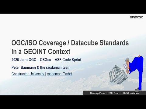
"Coverages" in standardization represent data that vary in space and time (6min intro video). Most prominent are geo datacubes which unify regular and irregular gridded data, such as 1-D timeseries, 2-D imagery and DEMs, 3-D x/y/t timeseries and x/y/z geophysical data, 4-D x/y/z/t metocean data, and many more. The data and processing model of coverages/datacubes is defined in ISO 19123-x / OGC AT6.x. In 2026, a backwards-compatible update of ISO 19123-2 Coverage Implementation Schema (CIS) has been adopted by ISO and will now be brought back into OGC.
In this tutorial, the spec editor will introduce to coverage concepts, structure, and applications in XML and JSON also making use of the ISO/OGC geo datacube query language, WCPS. Hence, no coding background is required. Many of the live demos shown can be recapitulated by the audience. Questions and discussion are very welcome.
Resources: 6min intro video, sprint webinar slides, EarthLook hands-on demo service, Cube4EnvSec interactive aviation weather demo
Technologies: rasdaman distributed datacube engine (OSGeo community project, OGC WCS reference implementation, EU INSPIRE Good Practice)
Requirements: Basic understanding of geo raster wrangling
Stream leader: Peter Baumann
Proposed schedule: 27th of January, 11:30 - 12:15 GMT-7
Sprint availability: reach out to Peter Baumann by mail [email protected] - he will respond as soon as he is up in the morning (CET = UTC+1).
This presentation will introduce OSH Connect, a family of client application libraries intended to provide a simple and straightforward way to interact with OpenSensorHub nodes via the OGC API - Connected Systems interface.
Technologies: python
Stream leader: Robin White
Proposed schedule: 27th of January, 13:45 - 14:15 GMT-7 - https://www.timeanddate.com/worldclock/meetingtime.html?day=27&month=1&year=2026&p1=224&p2=179&p3=16&p4=44&p5=240&p6=136&p7=133&iv=0
This tutorial will cover the following sections:
- High level introduction of what can be done with HEIF.
- Selected deep dive into the structure of the file.
- Some examples.
- Introduction on how to use the LibHeif API.
Stream leader: Joan Maso and Dirk Farin
Proposed schedule: 27th of January, 15:00 - 15:45 GMT-7 - https://www.timeanddate.com/worldclock/meetingtime.html?day=27&month=1&year=2026&p1=224&p2=179&p3=16&p4=44&p5=240&p6=136&p7=133&iv=0