admin ESTABLISHED STANDARDS - fieldmuseum/EMu-Documentation GitHub Wiki
Shared between modules
Data Norms
Contributor Role
ebibliography; emultimedia
We limit these to values in the Dublin Core role list/definitions.
Lookup List
Language
ebibliography; eparties
We use the ISO 639 Language List for acceptable values.
Lookup List
How to interpret qualifier field values in EMu
- See: https://github.com/fieldmuseum/EMu-Documentation/discussions/897
- You can find fields that use this lookup list in the Qualifiers file .
emultimedia
General DAMS standards
General Imaging standards:
EMu Databasing Standards and Appropriate Use
Cataloging multimedia - standards & protocols
File Naming conventions
- No special characters, diacritics or spaces should be used in filenames. Specifically, avoid these:
. , : ; - ~ ! @ # $ % & ^ * ` / \ () [] {} <> ? ' “ áÁàÀâ äÄãÃåÅæÆçÇéÉèÈêÊëËíÍìÌîÎïÏñÑóÓòÒôÔöÖõÕøØœŒßúÚùÙûÛüÜ
- Keep filenames under 100 characters -- Preferably under 50.
- Here's what can happen if you try to transfer files with longer names across network storage:
If the following does not cover your situation then this is a useful reference on naming conventions.
Action
- For event photos: [Event irn or short name][Photographer last name][sequence number]
e.g., "MembersNight2019_Suwa_1.jpg", "7781_Smith_2.jpg"
Anthropology
- For objects: "CatalogueNumber_Angle_Side"
- For catalogue cards: "CatalogueNumber" + "CC" + "front"/"back"
Botany
- "Barcode" + "[summary data from the catalog record it attaches to, taxon]"
e.g., "V001234F.jpg"
Conservation
- Project code_Catalog number_subnumbers (if any)_Shot description_ETC tag (if any).Filename extension
e.g., "CV2286_9725518_1_CaseInterior_ETC.jpg"
Exhibitions
- For object-specific images: "ExhibitObjectNumber_description_optional_EX"
- Remove dashes ("-") in Exhibit Object Numbers.
e.g., "AAD013_snap_EX.jpg"
Geology
- Collection prefix_specimen Catalog number_suffix (if any)_descriptive term
e.g., "PE100a_label.jpg", "PE100a_lateral.jpg", "PE100a_closeup.jpg", "PE100a_view2.jpg"
Fossil Prep Lab:
- Field number_Sequence number_Collection code
e.g., "UT130994219_1_PR.jpg"
Photo Archives
-
Deptcode (A/B/GEO/Z/GN) + Neg# + _ + negsub# + c or d;
e.g., "GN92442d.jpg"
Repatriation
- For correspondence and agreements (e.g., MOUs): "[Tribe/Group/Person-name]_[Document Type]YYYYMMDD[optional brief document title]"
e.g., "Wiyot_Agreement_20170120.pdf"
Zoology
- (and specifically Insects) "Catalog number_Descriptive info_Division abbreviation"
e.g., "999999_Genus_species_typestatus_view_IN.jpg"
Others
For ledger-book scans:
- Volume# + catalog number range (e.g., "1_4000" = 1 to 4000) + (Ledger Series Name, if any) + Collection
e.g., "Vol1_1_4000_InvertsCat_IZ.pdf"
Documentation for photo-shoots or projects with Event #s:
- "[project#]_[optional sequence ##]_delivery_email.pdf"
- "[project#]_[optional sequence ##]_request.pdf"
- "[project#]_[optional sequence ##]_notes.pdf"
- "[project#]_[optional sequence ##]_release.pdf"
- "[project#]_[optional sequence ##]_MEO.pdf"
If not sure what kind of email/correspondence, use:
- "[project#]_[optional sequence ##]_correspondence.pdf"
MorphoSource: [Institution code][Collection Code][Catalog #][Genus][part, if specified]
e.g., "FMNH_M_12345_Genus_cranium.zip"
2D Still images
Audubon Core
(Natural History Media Standard based on Dublin Core)
- Mapping fields between EMu emultimedia & Audubon Core Googledoc mapping
Embedded Metadata for Images
- Rights - “(c) FMNH - CC BY NC” + Year [KW]
- WebStatement = URL for online licensing terms
- This will pull from the rights record (new field for URL for WebStatement)
- For collections images this URL is https://www.fieldmuseum.org/preferred-citations-collections-data-and-images
- GUID (Multimedia ac:identifier) -
- Occurrence ID: catalog GUID
- Resource Type
- Date Created
- Language of Metadata (Details tab -- DetLanguage_tab )
- Title
- Creator
International Image Interoperability Framework
3D Media
- Community Standards CS3DP (Community Standards for 3D Data Preservation) -- overlaps with Audubon Core
Audio/Video
Controlled Vocabs for Resource Types
URLs
Only make Multimedia records for URLs that reference online resources -- i.e., NOT for online publications (which go in Bibliography) or resolvable specimen GUIDs (which go in Catalogue / as Associated records)
Standard File Formats permitted for a given Resource Type | Subtype in EMu
Resource Type "Dataset"
- CSV, ODS
- ZIP* or TAR* - for large or complex datasets comprising multiple files
- Resource Subtype "Sequence"
- ZIP* or TAR*
Resource Type "Image"
- Resource Subtype "3D model" = PLY, STL, or OBJ.
- For models that need to display & render online = GLB or GLTF.
- Resource Subtype "CT Data" = ZIP* or TAR* containing folder for 1 scan dataset (set of TIFF or BMP)
- Resource Subtype "Image Set" = ZIP* or TAR* containing folder for 1 image set (set of JPG, TIFF, or BMP files)
Resource Type "StillImage"
- JPG, DNG
- Resource Subtype "X-ray" = DCM or 16-bit grayscale TIFF
Resource Type "InteractiveResource"
- ZIP* or TAR*
- PNG for QR-codes or Bar codes
- URL for websites or interactive presentations (e.g., Google Slides)
- PDF for Powerpoint slides (PPT or similar formats) if a URL does not exist
Resource Type "MovingImage"
- Resource Subtype "Video" = mp4 or mov
- Resource Subtype "Animation" = mp4 or mov
Resource Type "Software"
- Contact IT if archiving software or scripts - [email protected]
Resource Type "Sound"
- MP3, WAV
Resource Type "Text"
- Resource Subtype "Document" = TXT, PDF, or ODT
- Resource Subtype "Permit" = PDF
NOTE - * - ZIP or TAR files should include a ReadMe file (PDF or TXT format) describing how the files in the ZIP/TAR were produced (e.g., a CT Data ZIP should include a PDF or TXT ReadMe listing scan settings and other scan-related metadata)
ebibliography
APA Citation Standards
- Library of Congress - http://www.loc.gov/teachers/usingprimarysources/apa.html
Citation Numbering
The Field Museum follows the Chicago manual of style (2017) for citation formatting. All numbers EXCEPT page numbers which are printed as roman numerals should be converted to Arabic.
Enter different sequences of page numbers separated by comma, space. If a range starts at the first number in a sequence, it is not entered as a range. examples:
- xvi should be entered as “xvi”
- 1-999 should be entered as “999”
- 517-520 should be entered as “517-520”
Publication City
The name of the city in which the journal was published. For US publications enter City, State abbreviation, for non-US enter City, Country from ISO list examples: Chicago, IL; Paris, France.
Cataloguing PDFs
- [For publications not available online] (http://intranet.fieldmuseum.org/sites/default/files/BibliogPDF04.pdf)
- Publications in EMu (Bibliography Records)
- How to catalog publications
eparties
How to handle "et al"
Only when multiple (more than 2) individuals are unknown should the “et al.” Party record (irn 5645) be attached in collector, author or other party-attachment fields.
Names with articles (e.g., “Thaís de Agostini”)
Make sure the article is in the Last Name field (e.g., irn 205778)
Recording people when no name is given (non-name records)
For example:
- title
- role
- position
- description
- Create an FMNH Master ‘Person’ record with NamBriefName = [what’s on the label]
For people with only a single name e.g. Cher
- Create a Person record with only NamFirst
- Set ‘Automatic’ fields to ‘No’ see also eparties Topic 26: How to handle Person records with only 1 legal name?
Personal names
- http://viaf.org/ links to national name authority files from around the world (including LC) and testing links to others (wikidata, ISNI)
- http://id.loc.gov/authorities/names.html Library of Congress name authority file
- https://orcid.org/ -- registration service for unique identifier for researchers (better for contemporary authors of articles rather than books)
Organisational hierarchy
esites
ALL esites STANDARD ISSUES
LMA's - Human-constructed areas
DECISION: Nov 2021 These will have a rank = “LMA” which stands for Land Management Area.
- This rank should be used for localities such as National Parks; State Parks; “SSSI’s etc. It follows this definition: "From google: A land management unit (LMU) is defined as: “A homogeneous block of land that responds in a similar way under similar management.” Areas that need different management or that will show different responses need to be separated for good planning."
e.g. Locality = Yosemite National Park; Rank = LMA
- If the park crosses political divisions then the parent should follow the rules for documenting uncertainty
Standard Country Names
All collections will use the ISO 3166 Country Names list (https://www.iso.org/iso-3166-country-codes.html; Search https://www.iso.org/obp/ui/#search) in the political hierarchy of all esites records country names. The official 2-letter code will be included in all Country records based on this value.
- See Also “Documenting synonyms and historical names” for information on how to handle names not found in this list.
Established Political and Island Hierarchies
Precise Localities
These are transliterations of the verbatim locality strings that have been cleaned and standardised:
- for use in georeferencing actions;
- as translations of non-English languages;
- as consolidations of duplicate site strings (e.g. Field notes vs label copy or botanical specimen duplicates.)
The following recommendations and agreed standards are also a good guide for creating locality strings for new collections.
General recommendations:
Abbreviations
Wherever possible, in order to remove ambiguity, abbreviations should be avoided and full terms used.
Exceptions: Agreed abbreviations e.g. cardinal directions and distance units that can be used. Any user may propose a new abbreviation to be added to the list by submitting it to the EMu user group agenda for discussion for power users.
Fractions and decimals
Be aware that conversion from a written fraction e.g. ¼ to a decimal e.g. 0.5 can have unintended consequences with regard to precision i.e. 0.5 is not the same as 0.500. Any such conversions for the purpose of georeferencing should be noted on the lat/lon tab in the georeferencing remarks field. Note that TRS fractions should not be converted to decimals.
Sentence Case and Capitalization
Wherever possible use proper sentence structure and capitalization i.e. capitalize the first letter, end with a period.
Hierarchical site information
Be mindful of entering data from the most general to the most specific and use a consistent delimiter that is not a comma e.g. “Yellowstone Park; Pines Trail.” not “Pines Trail, Yellowstone Park”. This will assist greatly when data is parsed into its parent/child hierarchy.
Parentheses/braces/brackets
Square brackets “[]” are reserved for indicating a lack of legibility in the verbatim locality string. They should not be used in the precise locality Text contained within “()” in a precise locality should be used to indicate an additional piece of information relevant to the locality. They should not be used for qualifiers which belong in the Collection Event or or alternatives see the Qualifiers Standard.
Repeated terms
Do NOT repeat the field name in the value unless it is a part of the official place name e.g. county or co.
Verbatim label locality strings:
When digitizing specimens the original locality string as documented on the specimen and should be entered as seen.
Distance measurements
Where there is a measurement of distance in the locality string put the distance first e.g. “1 mi. West of Chicago” not “Chicago, 1mi. west”.
Geographic Ranks
Should not be abbreviated. They should also not be entered into the state or county fields e.g. “Cook” not “Cook Co.”
Use of the word “The” in a country name
Unless it helps to disambiguate two country names then we will NOT include “The” in the name (at the beginning or end). So for example the country level record for “The Bahamas” will say “Bahamas”.
Specific discussions where the rule may be reversed are documented here: https://docs.google.com/spreadsheets/d/1vjh-QNcr93Jla8YVrfbooLqj5YY6xZF48-yp8cLhvkA
See #51 for discussion
Continent names and codes
https://planetarynames.wr.usgs.gov/Abbreviations
Valid Options:
- AF: Africa
- AN: Antarctica
- AS: Asia
- EU: Europe
- NA: North America
- OC: Oceania
- SA: South America
Ocean names
Oceans should be entered WITHOUT the word Ocean at the end. Marine Waterbody boundaries are as indicated in the IHO Limits of Oceans and Seas publication https://iho.int/uploads/user/pubs/standards/s-23/S-23_Ed3_1953_EN.pdf
Valid options:
- Pacific ** North Pacific ** South Pacific
- Atlantic ** North Atlantic ** South Atlantic
- Indian
- Arctic
- Southern
Country codes
https://www.iso.org/iso-3166-country-codes.html
UN Ocean Data Standards Volume 1: Recommendation to Adopt ISO 3166-1 and 3166-3 Country Codes as the Standard for Identifying Countries in Oceanographic Data Exchange
City lists
http://www.unece.org/fileadmin/DAM/cefact/locode/usa.htm
Uncertainty
Continents and Oceans
- Updated May 2023: Continent should never be NULL use
Marine Waters(irn 734114) for places that are in the sea but outside of any national boundary. UseInternational Waters(irn 695422) where this is known.
Country (PD1), PD2 and PD3 Levels
- It is acceptable to have multiple values in Continent/Country/PD2/PD3 or Ocean. Use (lowercase)
andororas a separator however continent, country and ocean values MUST be from one of the valid Names lists.
Qualifiers
When there is uncertainty about a location, for example when you e see or would want to use a question mark in the locality or name fields STOP - don't. This belongs in the Collection Event that is connected to the catalogue record.
TRS data
Township
- Integer[N or S]
Range
- Integer[E or W]
Section
- Integer(1-36)
Quarter
- [SE, SW, NE or NW] + “ “ + “¼”
- [N, S, E, W] + “ “ + “½”
- “Corner” [Southwest corner of section 28 or Northeast corner of NE¼ of Section 6]
- “Centerline” [East-West centerline of Section 29 or North-South Center line of …]
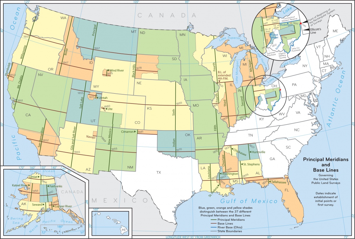
Meridian
- Name of Meridian from List of Principal Meridians http://www.pmproject.org/ https://www.blm.gov/sites/blm.gov/files/meridianmap09_1.jpg
- Fraction values - Use ¼ or ½ NOT a decimal value
References: Jacksonville State University Dept of Geology Definitions | Wisconsin DNR | (USGS)
Georeferencing Best Practices
Follow these guidelines and best practices where possible:
https://docs.gbif-uat.org/georeferencing-best-practices/1.0/en/
Documenting who did the work to georeference a record.
Collector Assigned
- At the 13 December EMu User group meeting it was agreed that the phrase "Collector Assigned" would be used when a georeference was acquired from the actual collector (either because it is written on the label or was found in a collection/field notebook).
How to document dual place names
Some place names are in two languages that have equal status. For example some official place names in New Zealand are dual names, incorporating both the original Māori place names and the English names given since European settlement, incorporating both the original Māori place names and the English names given since European settlement.
- In EMu these should be placed in the field as written following the rules of that place so for example
Ahukawakawa (Sphagnum Moss Swamp)
elocations
Google presentation h#cTG#
- h# = WHat hall it is in
- ctG# = What case it is in (assigned by developers) TG Indicates temporary gallery
- C3 = Case numbers in permanent gallery