Final Report - ayoubft/Journey-GSoC-21 GitHub Wiki
Integrating a module to 3d scan a house within the MapMint4ME android application (OSGeo - MapMint)
- About
- Abstract
- The state of the art BEFORE GSoC
- The added value
- Future Work
- Permanent links & documentation :
About:
| Student | Mentors | Organization | Dev Community |
|---|---|---|---|
| Ayoub FATIHI | * Samuel Souk aloun * Fenoy Gérald * Rajat Shinde * Venkatesh Raghavan* Sittichai Choosumrong | OSGeo | MapMint |
Abstract:
This project allows a minimalist 3D scan (taking multiple pictures, recording camera position, using opendrone map to rebuild the 3D scene) with the house faces (accessible/visible faces) then load it as 3D model and export the data back on MapMint for 3D viewing.
The state of the art BEFORE GSoC:
Have you ever wished that you could easily transfer a real object into a digital file? The technology is here, but most of us simply do not have access to high-end 3D scanners that can reconstruct the digital geometry of a physical model.
The added value:
Now it is possible to take multiple pictures using MapMint4ME, then visualize the 3D model issued from the taken pictures in MapMint.
Future Work:
- One challenging part of my project, not yet done, is to get to link the MapMint4ME with a MapMint instance.
- I did not get enough time to automate the step of creating the model using openDroneMap, here is what i was thinking to do.
Permanent links & documentation:
Code Repositories:
Videos:
Other Important Links:
Documentation
My work consist of three parts:
- One graphical image describing my project:
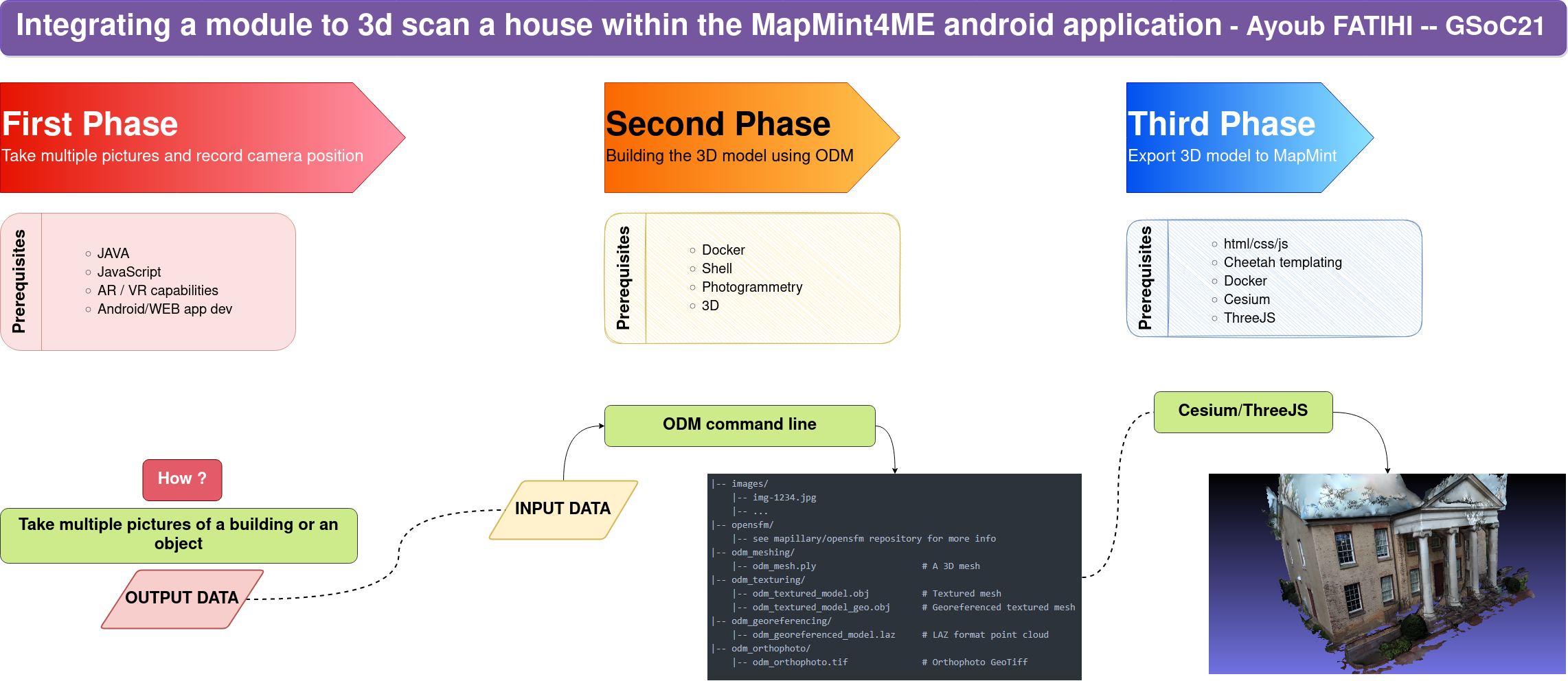
Part One: Get the pictures using MapMint4ME
Here are the commits for this part.
- Created a button that direct you to the this layout.
- I have created a form that can be filled with a fixed number of images taken from the mobile MapMint4ME app, and will be transfered to MapMint, here is how to do it.
- I have some issues regarding linking MapMint to MapMint4ME, so I did get the datasets for buildings from here, and I have taken the tajjin pictures by myself.
Part Two: Create the 3D model using ODM
- I have created a 3D model from pictures, here is the tutorial.
Part Three: Visualize the 3D model in MapMint
Here are the commits for this part.
- Got MapMint working on virtual machine tutorial here, then I finished up with configuring it on Docker tutorial here.
- Added 3D models to the volume see here.
- Used docker volumes to get access to the 3D models to be visualized.
- Using threeJS, I was able to render the 3D models in MapMint, using a template.