Labeling a Parcel Fabric with the Maplex Engine - anthonyblackham/GIS-Wiki GitHub Wiki
When labeling thousands of features automation is required to maintain your sanity. Annotations are nice but they don't scale. The Maplex Engine has many helpful rules and algorithms to aesthetically label many features.
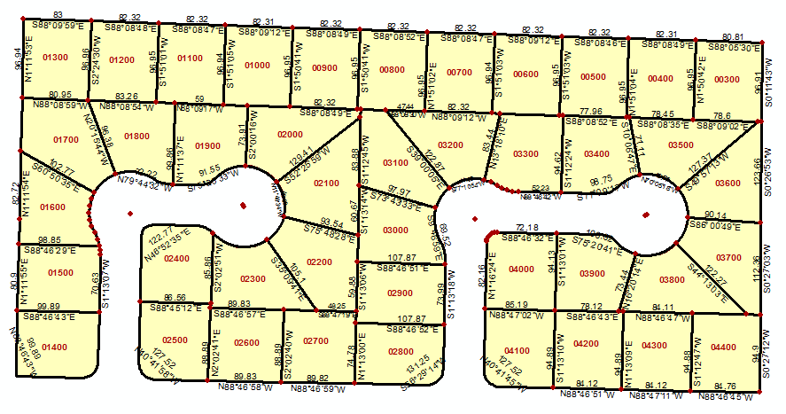
The options for labeling parcel fabrics are endless. For my purposes I am mostly concerned about parcel numbers, bearings, and distances.
Labeling Lines
Label Position Regular Placement Straight and offset from line
Fitting Strategy Only have reduced font size checked with a lower limit of 5 points
Label Density Label buffer: 15
Conflict Resolution Feature weight: 600
In the attribute table for my lines layer I modified the distance field properties to round to two decimal places.
You can also do some expressions and rule based rendering to label the line with a bearing above and the distance below.
I used the Straight and centered on line placement with the following label expression:
[Distance] + "\n" + [Bearing]
could be cleaner with some tweaks but gets the information I need.
Labeling Polygons
Set to land parcel placement and tweak as necessary.
I have full parcel numbers but the lot number is only the last 5 digits and that is all I want to show in my map. I used a python expression to slice the last five characters. Make sure the python parser is selected and the advanced box is checked
def FindLabel ( [Name] ):
  return [Name][-5:]