Add a location - Archilegt/Myriatrix GitHub Wiki
This is a modified and extended version from the original tutorial.
- From the Admin menu go to Content.
- Go to the content type Location and click on Add.

- Enter a unique location identifier.

- Add a georeference. Two options are available:
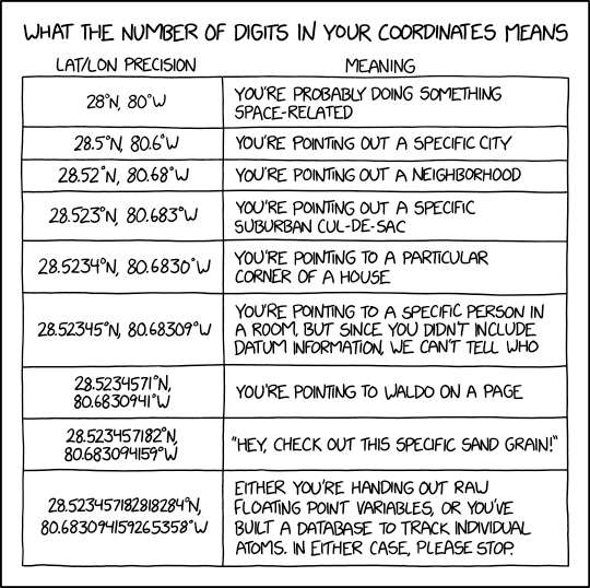
- Option 1. Adding a point: Click on the Point tab, left-click on the desired place for the map to add a point. The point can be deleted with right click if necessary. Note that the field "Point" under the map will be populated with decimal latitude and decimal longitude with 14 decimal places. That level of precision is undesired, unless you are mapping molecules or atoms. Keep false precision at bay by manually truncating the string to a maximum of five decimal places. Round the last digit appropriately.

- Option 2. Adding coordinates: Enter the decimal latitude and decimal longitude in the field below the map. Limit your decimal places to a maximum of five.

- Click on the "Extra Fields" tab for additional optional fields.
- Select a Continent/Ocean from the drop down menu.
- Select a Country from the drop down menu.
- Use the Locality field to enter information that is not covered in any of the fields above.
- Fill the field "Geodetic Datum". If you used georeferencing option 1, the geodetic datum of the displayed map is WGS84.
- Fill other fields as desired. If in doubt, consult the Darwin Core quick reference guide.

- Click Save.

A quick and funny guide to what the number of digits in your coordinates means:
Permanent link to this comic: https://xkcd.com/2170/